|
To shift or not to shift�(part
2)
|
|
|
|
Last time I elaborated a little bit about the concept of oscillating or persistent shifts. I've
I've tried to make clear that:
A) Knowledge of interaction between continental systems and their development with the local systems like; convection or seabreeze etc. will be a lot of help anticipating the shift during the leg or race.
B) With this knowledge it's essential to start looking at the signals from the clouds, wind, water etc. These can tell you in "Real time" what's actually happening.
Don't forget that in order to predict the weather there is a lot of modelling and calculating done by computers. And a scientific mathematical model to calculate the data measured on millions of weather measurements all over the world is still a model; "a desperate attempt to describe the real world". And that's still a liability if it comes to instant decision making on a local situation like a 50 square meter environment in which the racing takes place.
So after the observation we go to the analysis from the weather bureau and try to make sense of what's going on "on the screen" and on in "Real Time" on the course.
This time I will try to show you how to start using the "knowledge from meteorological and Real Time observations" into the decision making in the boat.
As we know by now. It all starts at getting an idea on if and how the gradient will develop over the day. Mostly a surface analyses and a forecast on how the closest High Pressure, Low Pressure or Frontal zone will develop, is enough to get this idea. Then it's time to get some idea on how the local system will interact with this.
Let's take an example: We're racing in Medemblik (site for our phenomenal event the Spa regatta). A low-pressure areas over the Queen's Island (GBR that is) is moving away towards the northeast usually comes with a sector west gradient wind which is veering during the day. To present this graphically:
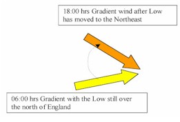
So if it's not completely overcast and both land and water temperature have dropped significantly overnight there's a good chance of thermal effects during the day, and interacting with this veering gradient.
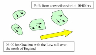
This will mean that at from about 10 am we need to be alert for the increased visibility (disappearance of the haze) plus a possible development of small and relatively cumulus development as a sign that morning convection can happen. If nothing weird is happening (like the approach of a warm front) there's a good change of gusts (patches of more and/or backed/or veered wind between 10 secs and 3 min) with veered winds (sometimes up to 15 degr) with increased windspeeds (up to + 5 kts). This gusty period can last between 15 min. up until 2 hours. Possibly a seabreeze will establish afterwards.
So on the course and during for instance an early race graphically it could look like.
fig2.
Let�s say we�ll have a starting time at 10:00 hrs. If
we�re on our way to the racing area (and take
the laid back option of being towed out!!!), we
can already start to look at the way the wind is
behaving. So how strong is the main wind? Do I see
any gusts on the water? How fast do they move? Do
they move with the main wind direction or do they
come from a particular side or from a different
direction? How is the direction of the wind at the
edge of the gust? And how in the middle? For
instance from the right in this particular case?
How is the course oriented to the coast?
(�because that big flat area there could explain
why there always more gusts on the left side of
the upwind��)
Once on the course and after tuning your boat for the
first upwind conditions, you have to start
checking the numbers (i.e. have a look on the
compass). Just sail full power away from the
starting vessel on starboard tack and check the
compass bearing, and keep on checking it over the
next 3-5 minutes while sailing full power on this
tack. You will (hopefully) find out that the
numbers on the compass will increase during the
gust and decrease after the gust. Try to be very
conscious of how this all looks on the course
oriented to the topmark if you�re lifted and
what it all look like if you�re fully headed. Do
the same thing on port for a while. The more time
you�ll spent doing this the more you�ll get an
idea on how it looks without all the boats around
and with the numbers on the compass as a back up.
Fig3.
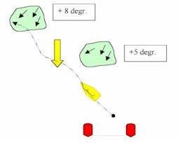
With the very good chance of convection present during the first beat, keep an eye on the way the gusts change over time and try to imagine what tactical situations will look like during the race. For instance when this gusts is just about to hit you while trying to fight off a group on you windward hip. And same situation when the gust just passed.
With this in mind you'll return to the starting area (in time!!) and start your pre-start orientation and make your plan on where to start and how to sail the first beat. After maybe four or five times of this kind of race preparation you'll be more aware of oscillations and persistent shifts and you'll definitely get better races in.
Let's continue with this example racing day.
Later, that day the wind will predominantly consist out of the interaction between the gradient and the seabreeze. The gusty period (convection) and the onset of the seabreeze (a big lefter about 20 degree that day) have all passed and took their toll during the races before.
Than we get 16:00 hrs. Now at this time with the dropping of the sun, it's possible to feel the intensity of the sun dropping the likelihood of the offset of the seabreeze local interaction with the gradient is getting closer. Don't think it's just switching a knob and this extra vector from the right is just gone�..
It's always an unstable period (with more gusts and lulls than you've seen all day or at the onset) and than a slow dropping of speed and depending on where the gradient was suppose to turn to, a gradual turning of the wind (between 18:00 and 22:00 hrs depending on how strong the breeze system really got and all the other factors).
So again you're going to race in shifty conditions but with pressure dropping (so power up your settings!!) and there might be a tendency towards the forecasted north westerly direction.
But hold on!! Seabreeze is starting in southwest and also slowly veering? And than with the offset�.??? Yes it might actually veer further than the local effect of the breeze system because of the gradient changing during the day!!! So what will happen?? To be honest
I'm not sure but at least with the expectation of a dropping of the speed and a shifty period during the races a lot of the big game plan can be made, and situations anticipated.
I hope to have showed you in which way simple principles can work for you in the praxis if you know how it looks! So start looking up at crucial intervals! It helps you to become aware of the system and translate the forecast of the Met bureau into Real Time decision making.
"We're going to have to be smarter than the wind," somebody once said. I wouldn't say smarter ("cuz' the wind ain't that smart") but more "aware of the principles that it's driving it".
Good winds
Rigo de Nijs
|